Day 1: Sunday, June 25
We got a later start than we had originally hoped. We had planned to pack most things up yesterday, on Saturday, but various errands interfered and we got little done before heading off to the Bob Dylan concert last night. The concert was good, though, and worth the trip. Dylan was the first half of the concert, and he was performing with what remains of the Grateful Dead. We left at the second half, during which Meredith had her first brush with a drug dealer! So we got up at 8 this morning, started packing, ran to Wal-Mart for some last minute supplies (including a camp stove), and finally made it out the door at about 2 PM.
We stopped in Bakersfield for dinner at a Mexican restaurant. Good food, except for the upset stomachs it caused later in both of us. Alas.
Meredith drove Mike's car for the first time, and even managed to start it on a hill! She drove the second leg (from Bakersfield to Barstow), where we stopped at a motel for the night. Barstow is famous for being a stop along Route 66, and not much seems to have changed since 1947, when the town was founded.
Day 2: Monday, June 26
We got out of the motel by 11 and had lunch in a local diner, the Route 66 Cafe, where we got our kicks. We hit the road and stopped in Las Vegas. Meredith had never been to Vegas before, although Mike had once spent six (long) days there a few years back at the NAB convention. We visited M&M World (which was huge), bought a magnet and some ice cream, and headed back onto the road. During our brief stay there, Meredith wondered why none of the M&M promotional films featured the brown M&M, since it is the most prevalent color in the package. Racism reigns. Trying to leave Vegas, we hit I-15 just in time for rush hour, but it was thankfully short.
We continued up the road until St. George, UT. I-15 cuts through Arizona for about 25 miles between Nevada and Utah. The drive was really pretty through there -- kind of a taste of sights yet to come. We found another motel in St. George and decided to again try a local restaurant, or at least one that we didnt have in California. Called "The Pasta Factory", it is one that neither of us would recommend for anything. The menu featured helpful definitions of terms like "marinara" and "spaghetti" to help demystify all that "funny Italian food." Oh well. We cant win every time.
Day 3: Tuesday, June 27
After checking out of the motel, we re-supplied at a nearby grocery store and then headed east. We stopped for lunch in Kanab, UT, at a restaurant called Nedras Too. (The original Nedra's is across the Arizona border in Fredonia). The food was delicious. After lunch, we headed east on various highways until turning off south on Highway 67 to finally head towards the North Rim of the Grand Canyon.
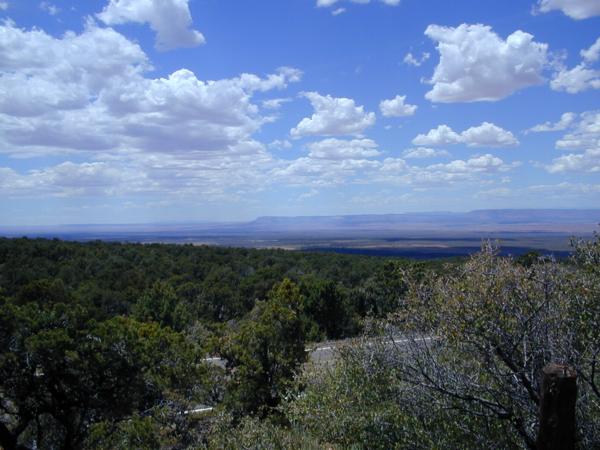
The road to the North Rim travels through Kaibab National Forest, which is where we hoped to do some hiking and camp for the night. Our first surprise, then, was the giant electronic sign as we neared the forest that stated "National Forest Closed". At least the sign then went on to say "Grand Canyon Open". We had never heard of a forest being closed for Thanksgiving, so with tears in our eyes, we Oh, never mind. We suspected that the closure might have something to do with the additional signs stating "EXTREME Fire Danger".
Indeed, signs pronouncing it closed blocked off every trailhead we passed. Fortunately, though, the campground in the middle of the forest remained open. We pitched a tent at the campground at Jacob Lake, then continued south about 40 miles to the North Rim itself.
By this point, we were at about 8000 feet of elevation. We made two discoveries about this. First, you really can tell the difference, especially having just come from Mountain View (elevation: 97 feet). Second, Mikes car, an Acura Integra, really didnt like the altitude. It was definitely affected by the lack of air (as, we were soon to discover, were our own cardiovascular systems).
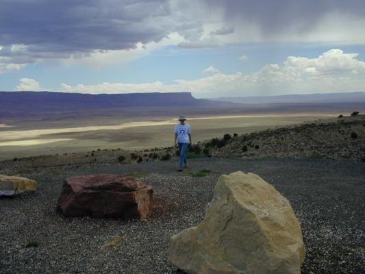
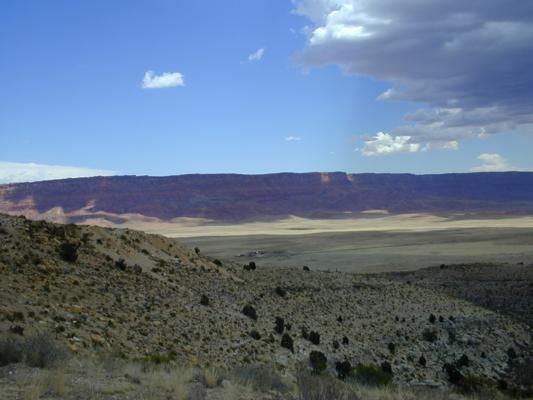
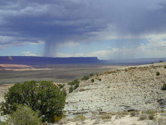
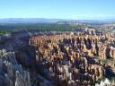
The Grand Canyon was amazing. Where we first saw it, its about ten miles across and a mile deep. Its hard to believe that a river did that, but when you give it a few million years to do so, it makes mores sense. We had arrived fairly late in the day, so we just took a couple of small trails (out to Bright Angel Point and Transept Trail).
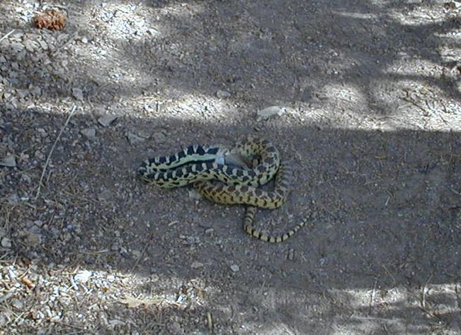
Coming back from Transept Trail, we came across a gopher snake (as later
identified by a park ranger from the picture) enjoying its dinner of a mouse.
Since we hadnt yet identified what kind of snake it was (or, more to the point,
poisonous or not), we decided to walk around the snake while it was still
engrossed with its dinner.
Giving evidence to just how extreme the fire danger was, we noticed that large parts of the forest around the park appeared to have been recently burned. Presumably because of this, several of the trails around the park were closed.
We eventually made it back to our campsite and cooked a pasta dinner on our camp stove.
Day 4: Wednesday, June 28
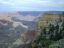 Images from the Grand Canyon |
We ate lunch in the park, then tried to hike part way down a trail (North Kaibab Trail) that ultimately leads to the Colorado River at the base of the canyon. Unfortunately, due to the aforementioned low energy, we didnt make it very far down before deciding to turn back. The trail was also used for the famous Grand Canyon mule rides, one of which we passed on our way down (you have to make reservations in advance to ride the mules). This also made the trail somewhat perilous to walk on in sandals, and more than a little smelly. But the mules were cool!
Following that failed excursion, we drove to another point (Cape Royal) in the park and walked out on the trails. The views were even more amazing. This location also afforded a view of the Colorado River, which cant be seen from the trails by the visitors center. The coolest part was looking at Angel's Window, an amazing square cut out of the canyon through which you can see the Colorado.
We spent some time just sitting there, enjoying the view and listening to a presentation by a park ranger on the history of the park (how it was discovered, how it became a park). He seemed to be a junior ranger -- after he finished his presentation, another man stood up and started reviewing notes with him. Afterwards, we went back to Bright Angel Point and watched the sunset.
Since it was dark by the time we left, we decided not to try cooking, but instead ate a really good dinner at Kaibab Lodge, about halfway between the park and our campsite. Mike ordered ice water; Meredith ordered hot chocolate. Opposites attract. One of the employees there told us that the National Forest was supposed to be reopening the following day. Bad timing on our part. Oh well. Driving back from dinner, we stumbled upon a porcupine in the forest. Also, for some reason, the Kaibab National Forest also has herds of free-range cattle, so we kept passing cows grazing in the drainage ditch. Mike drove, and Meredith was on "critter watch," a job that would prove more crucial later in the trip.
Day 5: Thursday, June 29
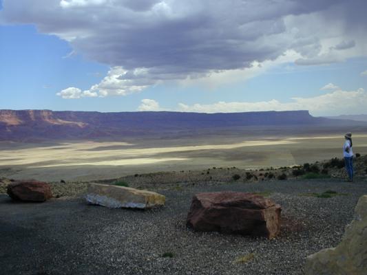 
Images from the Vermilion Cliffs |
We also stopped at Navajo Bridge on US Highway 89A. There are now two bridges that cross the Colorado River at that point. The first was built sometime in the 1920s -- truly a marvel of civil engineering at that time. The second bridge was built much more recently to replace the older bridge, which wasnt up to the stress of todays vehicles and traffic.
We ended up at the Comfort Inn in Page, AZ. Our card-key didnt work right after check-in until we went back downstairs and had them reprogram it. This was to be the first in a comedy of errors that we endured at this motel. Perhaps we should have been warned by the list of nearby attractions included in the motel brochure: "Glen Canyon Dam, Colorado River, Glen Canyon National Recreation Area, Wal-Mart". Wal-Mart? At least it had a shower, which was a welcome relief given that neither of us had managed to shower since Tuesday morning.
Page is the site of the Glen Canyon Dam, which created Lake Powell. The town was created when the construction started on the dam in 1956. It seems now that it exists as a tourist town because of Lake Powell. One wonders what happens to the town in the winter, though. (We overheard one waitress say that she just moves to Utah in the winter for the ski season.)
The dam was finished in 1963, and filled the lake for the first time seventeen years later, in 1980. We went to the visitors center for the dam and tried to take a tour, but they already full for the rest of the day, so we booked one for the next morning. The visitors center said that Lake Powell contains enough water in it to cover the entire state of Arizona five inches deep. The dam is one of several among the Colorado River that provides for flood control, water storage (for irrigation), and power generation.
After eating that night (at the Dam Bar & Grille), we decided to book a boat tour for the next day and extend our stay by a night. The desk clerk at the motel assured us that it would be no problem to stay another day.
Day 6: Friday, June 30
We toured the dam, which was pretty neat. They used to allow self-guided tours, but stopped after the Oklahoma City bombing. One wonders if it also has to do with the fact that some people are so opposed to the dam as to advocate sabotage of it (how insane can you get?). Afterwards, we ran back to the motel to grab some stuff before our boat tour, where the cleaning service asked if we were out yet. We explained that we were staying another day. Not a minute later, our phone rang. Upon answering it, Mike was greeted with "Are you out yet?" from the front desk. Mike explained yet again that we were staying another night and that we had extended our stay the night before with the desk clerk at the time.
|
We got back to our motel around 7 PM, went upstairs to our room -- and our key didnt work. Mike went back downstairs yet again to get them to reprogram the key. Clearly, extending ones stay at this motel is far easier said than done. On Mikes return trip up to the room from the lobby, the elevator had about six people in it and made horrible creaking noises. Given that the last inspection of the elevator expired in August of 1998, perhaps it is time to look at it again.
Dinner was at Peppers, the restaurant in the nearby Courtyard Marriott. Mike discovered a delicious micro-brew stout. Dinner was great, although both of us were starting to notice that all restaurants in this area fall into one of two themes: Mexican, or steak. The steak restaurants usually have one or two chicken dishes, and maybe one fish selection, but basically, Steak is it. Oh, and synthesized not-even-Margarine. How is it that you can have so much cattle that everyone seemingly eats steak every night, but you cant get real butter? Heaven help you if youre a vegetarian trying to eat here.
Day 7: Saturday, July 1
We got up early enough this morning to go downstairs to partake of the free continental breakfast at the Comfort Inn. Breakfast consisted of some cereal (but no bowls), one kind of juice, hot water (but no coffee), various types of bread, and a defective toaster. Mike discovered the fact that the toaster was defective when he noted smoke pouring out of it while he was waiting for his bread to be toasted. Evidently setting the selector switch to light meant nothing. Ten minutes later, someone else discovered this a bit later when his toast actually caught fire. Twenty seconds later, the fire alarm went off.
The point at which we stopped giving the motel the benefit of the doubt was when one of the staff was overheard explaining to another employee, "Well, someone didnt watch their toast." Another explanation might have been that the motel really should kick over the twenty dollars to replace the stupid thing, since it isnt entirely unreasonable for guests to assume that the toaster doesnt require constant inspection to avoid starting a fire. Toast flambé, anyone?
At least the fire alarm was very loud. Im sure it would have woken us up had it been a real fire. Which it wasnt.
After our laundry finally came out of the dryer, we headed out once again. Meredith had the idea to take Cottonwood Canyon Road off Highway 89, heading north through Grand Staircase Escalante National Monument. In addition to being a very scenic drive, it cuts about 50 miles off the loop.
Two and a half long miles (and about fifteen minutes) later, it was obvious that this wasnt going to work. Cottonwood Canyon Road is unpaved, but is listed in a brochure as being passable to passenger cars in dry weather. By passenger car, they do not mean an Integra. No doubt the road would have been a lot of fun in an SUV, or anything with higher clearance and more forgiving shocks. So we turned back, and continued west on 89 in the great loop to get to Bryce Canyon.
We stopped off again in Kanab and again enjoyed lunch at Nedras Too. Meredith had her first Navajo taco, taco fixings on top of fry bread. Yum!
We stopped off at the Red Canyon campground, about fifteen miles west of Bryce Canyon National Park. We pitched our tent and headed off to Bryce. We stopped at the staging area (staging for what?) and took the shuttle bus into the park itself. The shuttle bus had only been running for a few weeks when we arrived. It seems to work well.
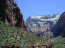
 Images from Bryce Canyon |
Dinner was at Rubys Inn. This restaurant was so big that most of the staff had wireless radios to communicate about table openings. The menu consisted mostly of various types of steak. How shocking. In the restaurant, we actually recognized the family who had set the toaster on fire in Page, AZ. You know you've been traveling too long when. . . .
Upon our very late return to our campsite, we discovered that our tent had collapsed. It seems that the very short stakes provided with our tents didnt really want to stay in the clay. We spent a while correcting this, made much more difficult by the fact that we were trying to accomplish this with no light save that from flashlights that we could carry. Mike got the bright idea to use his mag-light as a hammer, which helped drive the stakes in much more than before. Those flashlights are just indestructible. At least it worked, as the tent didnt collapse again.
Day 8: Sunday, July 2
We slept really well the night before. Having a tent on flat, not rocky ground really helps a lot. We spent a leisurely morning getting up and cooking lunch on our camp stove. The chipmunks were really interested in our food, but we werent giving any up. Meredith had several long chats with the chipmunks on the virtues of remaining undomesticated, but yea, verily, their ears were stopped. Mike discovered that he liked this campground better than the last one as it had showers. Yay!
Presumably because of the holiday weekend, Bryce was much more crowded today than it was the day before. Fortunately for us, most park visitors dont actually venture very far from the parking lot, so after fifteen or twenty minutes into a trail, most of the crowds are gone.
We decided to take a more strenuous hike today. We started out at Sunset Point, hiking down the Navajo Trail through what is called Wall Street. This is a series of switchbacks going between steep canyon walls. Pretty amazing. Our original plan, upon reaching the bottom, was to continue on the Queens Garden Trail back up to Sunrise Point. Instead, we decided to take the three-mile Peekaboo Trail, which mostly goes along the floor of the canyon (but with a lot of changes in elevation). The trail was well worth the time and hiking.
The views are just amazing. We took a lot of pictures, but no picture can really do justice to seeing this place.
Completing the loop, we headed up the Queens Garden Trail (so named because one rock resembles Queen Victoria) up to Sunrise Point. All in all, we hiked about six miles. By the time we reached the top, we were really tired.
We had dinner in the nearby town of Tropic, then went back to the campsite.
Day 9: Monday, July 3
We got up and made breakfast. Or at least we tried to. The wind this morning was just insane. When Meredith started taking down the tent, she got one stake out, and then the wind knocked the whole thing over. Good thing we were leaving anyway. We eventually wrested the tent to the ground and got it, and everything else, packed away.
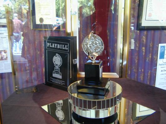 The Tony Award |
We ended up at the Best Western El Rey Inn (as opposed to the more expensive Best Western Town and County Inn two blocks down the road). Our friends Amber and Morgan, who went to college here, had advised us that Escobars was the only good restaurant in town, so we ate lunch there (Mexican, not steak), then came back to the room to just sit and read for a while. After a while, we headed off to find the Shakespeare Festival. We got tickets to a play for tomorrow night, and then ate dinner at Sullis Steak House (steak, you say?). Sullis is clearly going for the Irish theme. They have little metal leprechaun men on the tables, and green napkins, paint, and curtains. But the menu is steak and various Italian dishes. Go figure. The most notable decoration in Sullis is a montage representing the various iron works that have gone on in the area. Weighing over five hundred pounds with over 50,000 nails, it was mounted on a wall directly behind Mike. Every time Meredith looked up at it, she got the giggles. The centerpiece of the montage was a 300-pound chunk of ore. It was very odd. And very moving.
Day 10: Tuesday, July 4
We walked down Main Street looking for lunch and discovered that most of the shops in town, including at least half of the restaurants, were closed for the Fourth of July holiday. A very patriotic town this is. This made eating somewhat more challenging, but we eventually settled on Godfathers Pizza. Mike got coffee at "The Pastry Pub" afterwards, then Meredith took a much-needed nap for much of the afternoon.
For dinner, we ate at "My Cousin Vinnies" and then went to see the production of Noises Off. The play was hysterical -- well worth seeing. Mike almost fell out of his chair several times, especially when the stage manager, who hadn't slept in 48 hours, came on and tried to save the day. We went by the ticket office to get tickets to the matinee performance tomorrow of Merry Wives of Windsor, but were told that if we came by tomorrow morning, we could get free tickets.
The plan, then, is to go to the matinee, then head off to Zion, about 60 miles away. Well probably stay at Zion for two nights, then leave Friday for home, taking a couple of days to get there.
Day 11: Wednesday, July 5
Meredith walked down to the theatre to get our free tickets while Mike stayed and finished checking out of the motel. Getting the free tickets took a while, since a box office employee had mistakenly told people the night before that tickets for all the shows today were free, whereas in reality just two of the shows (Merry Wives and Cherry Orchard) were free. Since some people had driven hundreds of miles for their free tickets to Peter Pan, there were more than a few unhappy people in line. Oops. The performance of Merry Wives was excellent, though. The fact that it was free was certainly a nice bonus.
We found a room downstairs at the theatre with pictures from several past performances (the Utah Shakespeare Festival has been going on for 40 years now), where we got to see Amber & Morgan pictured from plays they had been in. . They look good in wigs. And not that much older. Really. Not at all.
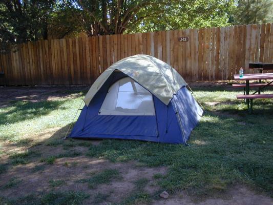 Our tent, cellblock J-13 |
We had intended to cook once we got to the campground, but decided that we really didnt want to spend any more time than necessary there, so we walked down the street into Springdale (or, as Mike started calling it, Little Gatlinburg) for dinner. We found a Chinese restaurant that was pretty good (if pricey). It was not Mexican. Or steak.
We walked back down the street into Zion and looked at the exhibits by the visitors center for a while before heading back to our parking lot for the night. We tried to take the shuttle into the park, but discovered that we would have to transfer at the Visitor's Center. Still, it was nice to plan the day ahead.
Day 12: Thursday, July 6
Last night proved that Mike can indeed sleep through anything, including people six feet away getting up, garbage trucks emptying dumpsters, and everything else. If only Meredith were so fortunate. . . .
It should be pointed out that Zion is a few thousand feet lower than either the Grand Canyon or Bryce. Because of this, Zion is a lot hotter. It was in the high 90s during our visit to Zion.
We ate lunch in the cafeteria at the Zion Lodge shuttle stop, then hopped the shuttle for the last stop and the river walk. The river walk was gentle and peaceful. Zion is an interesting place -- here you are in the desert, but with this river running through it creating some pretty interesting microclimates. Zion has what they term Desert Swamp, which is pretty accurate. We ended the day by walking up to Weeping Rock.
A lot of the vegetation was similar to what you would find out here in California. Perhaps because of the water there, the climates arent that different. Parts of the trail by the river were somewhat similar to the trails in the Smoky Mountains in Tennessee.
At this point, we decided that rather than spend another night in the parking lot, wed just leave. We packed up our tent, ate dinner at another restaurant in Little Gatlinburg, and took off. Some of the highways we took that night were just deserted. There was one seventy-mile stretch where we passed exactly two cars. It had a lot of wildlife, though -- we saw several deer, rabbits, and birds. And only hit a couple of rabbits. Rabbits must be suicidal. Oh, and one bird. Mike had never hit a bird before, but one seriously doubts that anything that size could survive bouncing off a windshield at 80 MPH. Oops. Meredith said a little prayer for the bird, and struggled to convince herself that it wasn't Mike's fault.
We made it to Ely, Nevada and spent the night in some total dive of a motel, where the shower door didn't close and every wall was a different color. All the other motels we had passed were filled up. Ely is so isolated that we could see the city lights from twenty miles down the highway.
Day 13: Friday, July 7
We got an early start (no incentive to stay one extra minute in the dive). US Highway 50 is deserted. There are signs billing it as "The loneliest highway in America." Not much but ranching and mining. Eureka, NV bills itself as "The loneliest city on the loneliest highway in America." Maybe US 50 isnt the loneliest in the US, but its probably in the running.
We stopped for lunch in Fallon at "Jerrys" (looking, acting, and tasting a lot like a Shoneys), and headed off. Thirty miles west of Fallon, we were on I-80 and headed home. There was a lot of traffic once we were in California, but fortunately, it was almost all headed opposite us. Meredith drove the last leg (from Tahoe on home) and remembered how much she hates mountain roads. Pretty stuff, though.
We made it home about 6:30, our vacation at an end.